Take a Second Look

In pursuit of second impressions

  • Stories
    • Archived Stories I
    • Archived Stories II
    • Archived Stories III
    • Archived Stories IV
    • Archived Stories V
    • Archived Stories VI
  • Photo Galleries
    • Gallery Archive - Africa I
    • Gallery Archive - Africa II
    • Gallery Archive - Africa III
    • Gallery Archive - Antarctica I
    • Gallery Archive - Europe I
    • Gallery Archive - Europe II
    • Gallery Archive - Europe III
    • Gallery Archive - North America I
    • Gallery Archive - North America II
    • Gallery Archive - Central & South America I
    • Gallery Archive - Central & South America II
    • Gallery Archive - Central & South America III
    • Gallery Archive - Oceania I
    • Gallery Archive - Oceania II
    • Gallery Archive - Oceania III
    • Gallery Archive - Asia I
    • Gallery Archive - Miscellaneous
    • Gallery Archive - Game Reserves I
    • Gallery Archive - Game Reserves II
    • Gallery Archive - Game Reserves III
  • About
  • Contact

The "House of Mary", Kusadasi, Turkey

November 13, 2017 by Rhyan Thomas

Kusadasi is a port city in the Aegean Sea on the west coast of Turkey. With more than 500 hotels it has become a bustling tourist and beach destination.  It is also the gateway to Ephesus with its historical attractions and the famous “House of Mary”.

You can find this small (reconstructed) house at 425 m elevation, hidden in the hills just above the ruins of Ephesus. What a great spot away from it all! To provide some background knowledge, allow me to refresh your memory of your Sunday school lessons (abbreviated version): John was Jesus’s favourite disciple. As Jesus was crucified, he asked John to care for his mother, Mary. John and the other members of the first Christian community really had a hard time in Jerusalem and decided to leave a) to save their lives and b) to spread the Gospel around the Mediterranean. John was assigned to Asia Minor (now Turkey). Naturally, because of Jesus’s request, Mary stayed with John. Both ended up in Ephesus – pagan country. The Ephesians loved their fertility goddess “Artemis”. Not exactly easy territory if you want to spread a new faith. So, John and Mary, together with their fellow Christians, headed for the hills where John built a house for Mary and himself. According to the Catholic Church, Mary lived until she was in her 60s and died (and was buried) in that house in the year 45 A.D. (see picture). How did the Catholics find the place? A (paralyzed) German nun connected spiritually with the Virgin Mary while in trance and was able to pinpoint the location. The troops were sent out to find the place and, voila, on July 29th, 1891 at 11 am a four-person expedition team stumbled across the ruins of Mary’s house. It matched exactly the descriptions given to the team by the nun.

Today, the reconstructed house is the destination of many pilgrims – Christian and Muslim. Yes, Islam makes mention of the Virgin Mary in the Koran. Chapter 3, Verse 42 states:

“Mary, God has chosen Thee, and purified Thee. He has chosen Thee above all women.”

Tourists come by the busloads. The site, and the natural springs around the house, are said to have healing qualities… as our guide says: “Push the button and drink the water.”

My impressions: regardless of the true history of this place, it is a special and very spiritual place. I can easily understand why people want to come here and allow themselves to be touched by the Divine.

John, by the way, continued to live in the house, evangelized in Ephesus (with Paul’s help) and died there at the ripe age of 96. He was the only one of Jesus’ disciples to die of natural causes.

November 13, 2017 /Rhyan Thomas
Comment
The sight of a cute toddler chasing pigeons is a welcome distraction after my visit to the Hiroshima Peace Memorial Museum. The museum is filled with witness accounts and pictures’ depicting the scene after the atomic bomb was dropped in 1945. The e…

The sight of a cute toddler chasing pigeons is a welcome distraction after my visit to the Hiroshima Peace Memorial Museum. The museum is filled with witness accounts and pictures’ depicting the scene after the atomic bomb was dropped in 1945. The experience leaves you stunned and numb.

Hiroshima, Japan

November 13, 2017 by Rhyan Thomas

It was a beautiful, crisp summer morning. Parents were walking their kids to school, retired people were watering their plants in the garden and dads were leaving home for work, when three large planes appeared on the horizon. After a night of air-raid warnings, the “all-clear” had just been sounded, so there was no need to fear the incoming aircraft. Children waved at the approaching planes when 600 m above the center of Hiroshima the nuclear bomb detonated. In that instant 80,000 people died and Hiroshima, a city of 350,000 inhabitants, was destroyed.

The date: August 6th, 1945. The time: 8:15 am. The nuclear age was ushered in and the world was forever changed.

For Japan, this was the closing chapter in a war that the country entered with much pride and arrogance. By 1945 though, most of the bigger cities in Japan lay in ruins from weeks of air attacks and firebombing by the Americans. With a severely weakened military, for Japan, the writing was on the wall. Still, as late as July 26 the country refused to surrender, sealing Hiroshima’s fate.

Despite its military importance, Hiroshima had been spared prior bombing. The Americans wanted to have a pristine target to be able to accurately determine the damage one atom bomb can inflict. But it was not until 7:15 that morning that the city rose to the top of the list of likely targets. The determining factor: the weather.

By the end of 1945 the number of fatalities had reached 140,000. Many thousands more would die painful and agonizing deaths in the years following the war from residual radiation exposure.

Hiroshima was re-built, playing an important role in the world as a deterrent for future nuclear attacks and as an ambassador city for peace. Despite all, new threats of atomic war and destruction at a much greater scale are on the horizon. But next time, we expect bombs with 1,800 times the power of the Hiroshima bomb.

A few years back I visited the Holocaust Museum in Washington, D.C. The same sadness and sense of collective shame that I felt then, I experienced this time as I walked through the Hiroshima Peace Memorial Museum. For me, taking in the images of human cruelty and suffering is not easy, but important. For the sake of our own sanity and the future of our children, I will never ever accept that nuclear war is inevitable.

I could have posted photos of bloated corpses floating in rivers or desperate mothers clutching their children as loose seared skin hangs from their bodies. Instead, I have attached a picture of a toddler chasing pigeons in front of the Peace Memorial Museum. Amazing how a shift in perspective can put a smile on your face.

November 13, 2017 /Rhyan Thomas
Comment
Not unlike the Atom Bomb Dome in Hiroshima, which was left standing as a constant reminder of war and a warning of its consequences, for me, the memory of my parents' recollections of growing up during WWII acts like a deterrent against any type of …

Not unlike the Atom Bomb Dome in Hiroshima, which was left standing as a constant reminder of war and a warning of its consequences, for me, the memory of my parents' recollections of growing up during WWII acts like a deterrent against any type of aggression.

War

November 12, 2017 by Rhyan Thomas

To me, important aspects to travel include surprises. Without them, travel would be predictable and boring. I had no idea, for example, that my trip through Asia would predominantly be about war. First Guam, then Iwo Jima, then Hiroshima, then Korea, then China, then Vietnam – all of these places are soaked in blood and bear witness to a violent (and not so distant) past. As I grew up in post-war Germany, I understood one thing very clearly: my generation WILL NEVER start a war. Yes, we will defend our country, but we will not be the aggressors. The memories passed down to us by our parents (and teachers) about growing up during WWII scared the living daylights out of us children. As I visit these countries with even more recent war trauma, I wonder if the same is true for their youth.

Our guide in Vietnam spoke of his country’s recovery effort. He has relatives in the US, has spent time in the US learning English and could move there if he wanted to. But unlike many other men and women I have met during our travels through developing parts of the world, he decided to stay in his war ravaged country. Noticing many encouraging signs that point towards a better future for his people, he wished more to be a part of Vietnam’s recovery, than to live a more comfortable life in the US. I very much admired his attitude.

~ RT 

November 12, 2017 /Rhyan Thomas
Comment

Iwo Jima, Japan

November 12, 2017 by Rhyan Thomas

The “Ring of Fire” is a circular geographic region of great volcanic and seismic volatility stretching from America’s west coast to Alaska along the coast of Russia to Japan. Volcanos and active thermal vents are lining the perimeter of the Pacific Ocean, evidence of age-old geological volatility in the region. The tiny island of Iwo Jima is part of that circle but that is not what this island is famous for.

On February and March of 1945 Iwo Jima was the site of an intense battle between Japanese and American troops. Equipped with three airfields, it acted as an early warning station able to notify the Japanese air defenses on the mainland of approaching US planes and to intercept enemy aircraft. The US needed the island as part of their staging area for an eventual invasion of Japan, as a landing site for planes damaged during attacks on mainland Japan and for re-fueling and servicing aircraft.. Prior to the land invasion, the island was surrounded by 450 US navy vessels which pounded the Japanese defenses intensely for several days, 6 hours at a time. The heavy artillery attack had limited success because the Japanese army had an entire year to prepare for the US invasion. They constructed bunkers, tunnels and other fortifications to hold off the attackers. When the first wave of 30,000 American Marines finally landed on the beaches of Iwo Jima, they were mostly greeted by eerie silence. It was only after the majority of the Marines incl. equipment had landed on the beach that the Japanese started firing from their defense positions, inflicting heavy losses.

However, the outcome of the battle was a foregone conclusion.  Despite their fierce defense, the Japanese were totally outnumbered and outgunned by the US Forces. Put yourself in the shoes of a Japanese soldier on Iwo Jima, watching as 450 !! war ships surround and start pounding the island for days. You know very well that eventually you and your comrades will be flushed out of your trenches by close to 70,000 invading US Marines.

Of the 22,060 Japanese soldiers entrenched on the island, 21,844 were killed. The US suffered 26,000 casualties, including 6,800 dead. Two Japanese soldiers continued to hide on the island and evade capture. They finally surrendered in 1951. After having seen the barren (tiny) island of Iwo Jima I wonder how they managed to evade capture and survived for so long.

The heavy losses on the US side caused many to question the feasibility of the attack on Iwo Jima and criticize this part of the American war strategy. What the critics did not know at that time was the top-secret reason for securing the island: Iwo Jima was to play an important role in the delivery of the atomic bombs by B-29 bombers.

Many years have passed since the attack but the respect for the bravery of the men who battled each other on this small island remains. As a gesture of reconciliation, groups of Japanese and US war veterans regularly meet on Iwo Jima to commemorate the events of March 1945. The power of forgiveness and grace!

~ RT 

November 12, 2017 /Rhyan Thomas
Comment

Unicorn Island, Vietnam

November 12, 2017 by Rhyan Thomas

Personally, I think it’s a stretch to compare Vietnamese wearing the traditional conical hats with unicorns. But there you go, never argue with the imagination of the people. As one of those who has never seen a unicorn, who am I to judge.

Named after the above, Unicorn Island is located in the middle of the Mekong Delta just a few miles outside of Ho Chi Minh City (Saigon).  With 6,000 inhabitants, the island is a haven for cottage industries that range from bee keeping to fruit production to candy making. During my visit here, I found people to be refreshingly industrious and polite. What I experienced was a glorious slice of Vietnamese life.

But where is communism? As mysterious as the unicorn, these days evidence of hard core communism is difficult to find in Vietnam, and as contradictory as the official governmental directives are from the officially espoused political philosophy, Vietnam is a country on the upswing; and that is a good thing, because people are happy to work for themselves and for their families.

~ RT 

November 12, 2017 /Rhyan Thomas
Comment

Ko Samui, Thailand

November 12, 2017 by Rhyan Thomas

“Verily, there is nothing new under the sun.” With these words E.W. Gudger closed his article in a 1920 issue of the “Natural History Magazine”. Without a doubt, he has made his point. Let me explain:

In the issue of “Science” for Feb 7th, 1919, Gudger published a note entitled “On Monkeys Trained to Pick Coconuts”. In his note, Gudger claimed that in the East Indies monkeys are employed to pick coconuts for their masters. Predictably, he was ridiculed for his remarks which prompted him to write an extensive article in the “Natural History Magazine” about the history of using monkeys for a variety of chores, including servants’ duties and coconut picking.

Among his listed examples of human – primate cooperation is the story of a monkey living in the Governor’s house in Cartagena, Colombia in the 16th century. The Governor frequently sent the monkey to the local tavern for wine. He placed the pot in one hand and the money in the other. When the monkey was met by children who threw stones at him in the street, he would set down his pot and cast stones at the children until they fled. Remarkably, even though the monkey loved to drink wine himself, he did not touch the wine he was carrying until his master offered it to him.

As Gudger lists his examples in reverse chronological order, he stops with a reproduced illustration from the tomb of Beni Haasan in Egypt, dated approximately 2,500 BC. (see picture) In this image one can see three monkeys gathering figs alongside their human masters. How many figs actually ended up in the monkeys’ mouths instead of the  baskets remains unknown.

In many tropical and sub-tropical countries the coconut is venerated for its culinary and non-culinary (e.g. religious worship) uses. In fact, the Sanskrit word (kalpa vriksha) for coconut means “the tree which provides all the necessities for life”. In the Malay language the coconut is referred to as the “tree of a thousand uses”. Needless to say, the coconut plant and its fruit play an important economic role in more than 80 countries around the world. More than 60 million tons of coconuts are harvested every year worldwide.

That’s a lot of climbing. While the majority of coconut plantations still use manual labour to harvest coconuts from 30 m (98 ft) tall trees, it is becoming increasingly difficult to find young people who are willing to do this dangerous work for very little money. Interestingly, the slow yet inevitable destruction of the caste system in India has resulted in fewer men from the lower castes climbing the tall trees.  They are now able to find jobs that are less physically demanding and more lucrative. Kerala, a southern state in India, is home to 15 million coconut trees which require more than 30,000 climbers to pick them.

So , if you can’t find workers for coconut picking, what are the options?

·       plant dwarf coconut varieties,

·       develop a coconut harvesting machine and

·       train monkeys to pick the coconuts from the trees.

While dwarf coconut tree varieties would be easy to harvest and even produce more coconuts per year, it is difficult to convince plantation owners and managers to switch to the shorter trees. The main reason: it is easy to steal the low hanging fruit. Often, plantations are thousands of hectares in size, making it impossible for owners to know when thieves steal the fruit from the trees at night.

Repeatedly, the industry has tried to lure inventors with cash rewards to develop a coconut-picking machine that would eliminate the need for humans to climb these incredibly tall trees.  So far, no one has come forward to claim the prize money, which leaves us with trained monkeys picking coconuts.

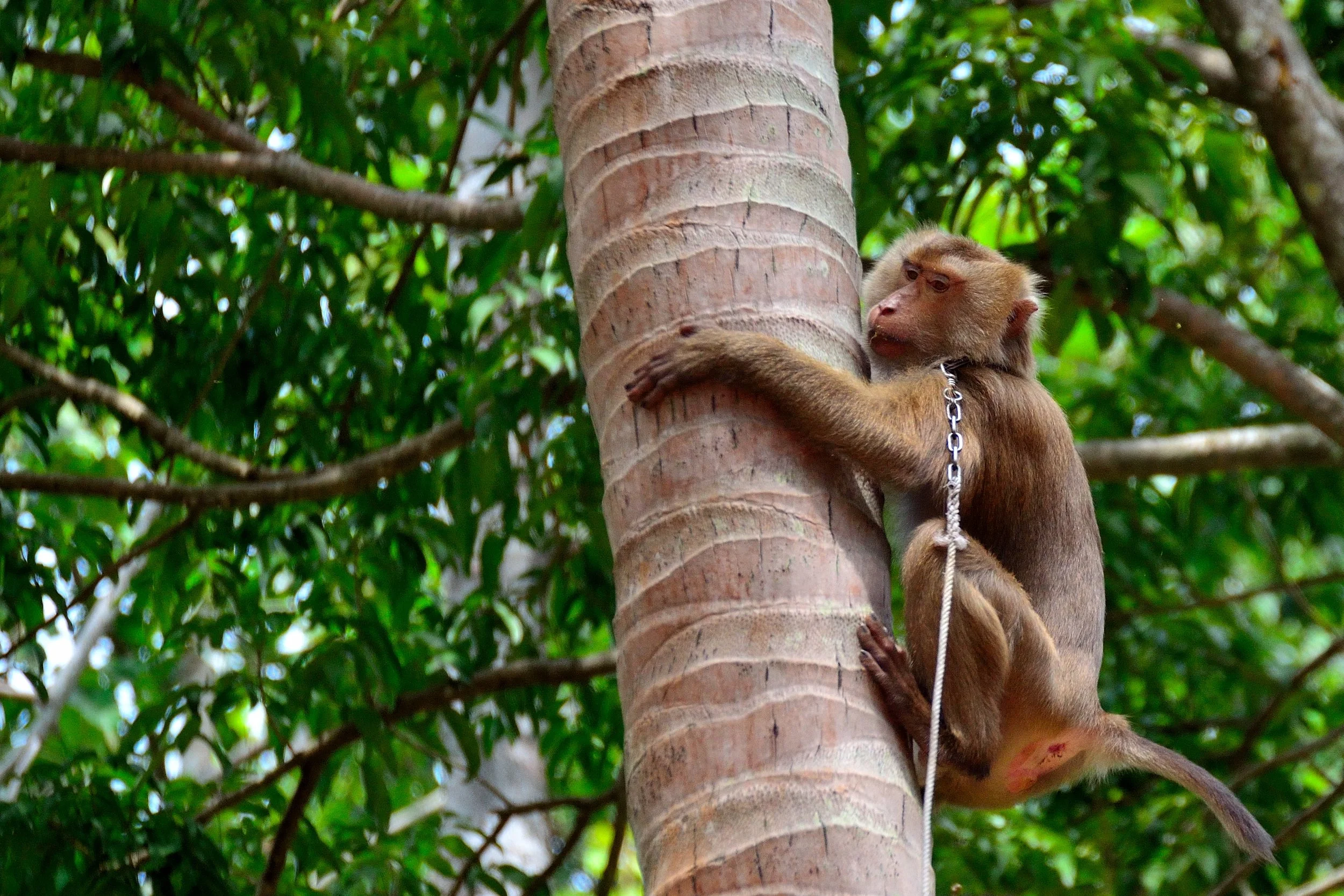
What is better than to choose the “coconut monkey” for the job? This monkey species, also called pigtail macaques (Macaca nemestrina) for their short and half upright tails, have proven to be easily trained and very fast. Male monkeys can climb up to 500 coconut trees and pick 1,000 to 1,500 coconuts per day (female: 600 coconuts/day). They are also preferred because females are less obedient (no surprise). Humans can climb up to 50 trees and harvest 300 coconuts per day. The pigtail macaques can grow as old as 25 years, half of which they spend working.

Here is how it works: the monkey climbs the tree with a collar and long leash around his neck. He can climb the 30 m in as little time as 1 minute. After reaching the top of the tree where the coconuts are located, he identifies the mature fruit, bites off the stem that attaches the fruit to the tree and allows the coconut to drop to the ground. If the monkey chooses an immature fruit, his master will pull on the leash, signalling that this coconut is not to be picked. In some cases, the monkey is trained to rotate the fruit until the stem twists off the tree. Verbal commands from his master are also used, for example when the monkey wants to climb down before all mature fruit have been picked.

Now you are probably wondering how the pigtail macaques are trained to perform such incredible work. In monkey school, of course! I am not kidding. Throughout Asia, schools exist that train monkeys to pick ripe coconut. One such school is the “First Monkey School” in Surat Thani, Thailand. Founded in 1957 by Somporn Saekhow, the son of coconut farmers, this school teaches monkeys at three levels: the basic training in “elementary school” during which the animal becomes comfortable with its trainers and learns how to climb trees and rotate the coconut. The monkey also learns how to free himself in case the line gets caught in the tree. During “secondary school” the monkey learns how to place the picked coconut in a bag and to carry the bags and drop them off near the owner’s truck. In “high school” the teachers can teach the monkey to perform almost any task desired by the owner. The cost: 6,000 Baht (US$ 200.-) for elementary and 25,000 Baht (US$ 800.-) for secondary school. Each of the two levels takes approximately 3 months.

Mr. Saekhow was motivated to establish the school after observing many owners beating their monkeys when they didn’t perform as expected (e.g. leaving ripe fruit on the tree). It became clear that frightened and/or angry monkeys did not perform well and were likely to bite. He was encouraged by his Buddhist teacher and famous monk Phra Buddhasa to use positive reinforcement and eventually developed his own teaching method. Mr. Saekhow died in 2002 but his daughter Somjai took over the management of the school. She still uses the same teaching methodology developed by her father. While visiting the island of Ko Samui in Thailand, Kit and I were lucky enough to see a monkey and his trainer in action (see pictures).

The destruction of wild habitat in South-East Asia has put the pigtail macaque species into the “vulnerable” conservation category. Ironically, it is the value of this monkey species to humans that may very well ensure its survival.

As I review the pictures I want to attach to my email, I wonder about the many human - animal partnerships that have existed over the millennia. If it is the horse or dog or falcon or elephant or monkey, there is much shame we ought to carry in how we, the human race, have treated our partners in this relationship. While avoiding the fanatic attitudes often displayed by animal rights activists, I am convinced that the correct approach to take in our partnership with animals is that of responsibility, compassion, care and respect.

I also wonder how the ancient Egyptians related to their animals. Did they treat their monkeys any differently 4,500 years ago? If Gudger’s statement “verily, there is nothing new under the sun” is true, the human race is still divided now, as it was then, between those who abuse and kill animals for their own benefit and those who protect and care for them. One thing I know with a high degree of certainty: we will not find or be able to develop a machine that can pick coconuts any faster and more efficiently than the pigtail macaque! How wonderful!

~ RT 

November 12, 2017 /Rhyan Thomas
Comment

Ko Samui, Thailand

November 12, 2017 by Rhyan Thomas

Let me introduce you to Dori, a young man in his early 20s. When the time came for him to leave his family home in northern Thailand, Dori’s parents gave him Sudalas, a young elephant cow that had already delivered two calves. Sudalas was to be his livelihood. When Dori left home, he packed up Sudalas, trucked her to the island of Ko Samui and started to work as a mahout (elephant keeper). The way Dori makes a living for himself and his elephant is by providing rides for tourists.

Traditionally, elephant keepers come from a long line of mahouts. As the life span of a person is roughly similar to that of an elephant, it is common for a young man to be given a young elephant as a means to earn a livelihood. Often, it is a relationship that lasts a life time. Being the owner/caretaker of an elephant is neither glorious nor easy; it is hard work. Every morning Dori takes Sudalas to the river where she is washed and scrubbed. Sudalas will also drink from the river. Urine and dirt from her night’s sleep have to be washed off. Then Dori has to collect branches and leaves for his elephant. Sudalas eats as much as 150 kg (330 lbs) of plant matter per day. The daily work routine involves taking tourists in pairs on a trek through the woods. The tourists sit in a carriage that is mounted on the back of the elephant. Dori drives his elephant forward by gently brushing his feet against her left and right ears. Specific instructions are given to his elephant through the use of verbal commands and an “ankus” (a short pole with a metal hook). Dori pokes Sudalas with the hook in the head, mouth and ear where the animal is most sensitive to touch.

From the moment Dori owned his own elephant, he lost his freedom. The two are joined at the hip and may spend the rest of their lives together. At age 40 both will reach their peak, they will know each other’s character well and their bond will be very close.

The spread of tourism in many south Asian countries has resulted in, what I call a “perversion” of the almost sacred bond between the mahout and his elephant. Rather than limiting their use to logging and carrying tourists, these majestic animals are also taught tricks that are supposed to please audiences. Asian elephants are known to be highly intelligent and self aware. Studies have proven their cognitive abilities to be similar to those of great apes. To me, seeing 4-ton elephants stand on two feet while playing hula-hoops with their trunks is not amusing.

For every 10 deaths among domesticated elephants in Asia, only 2 calves are born. Being the sole source of income for many mahouts like Dori, the animals are worked extremely hard. Pregnancies mean an interruption in income, something mahouts can ill-afford.

I find the concept of the mahout – elephant relationship both intriguing and heart-warming. A closer look, however, unveils a difficult and troubling life style for both, the man and his elephant. Far from the romanticised version we like to envision, giving your son an elephant as a means to earn an income is a poor substitute for a college degree!

~ RT 

November 12, 2017 /Rhyan Thomas
Comment
Mont St Michel in France continues to fascinate and mystify visitors from around the world. Third in popularity in France only behind the Eiffel Tower and the palace at Versailles, Mt St Michel attracts 3.5 million visitors per year. So much for mon…

Mont St Michel in France continues to fascinate and mystify visitors from around the world. Third in popularity in France only behind the Eiffel Tower and the palace at Versailles, Mt St Michel attracts 3.5 million visitors per year. So much for monastic solitude... 

Mont St Michel, France

October 26, 2017 by Rhyan Thomas


As we grow older, we realize with increasing clarity that we never “own” anything. We are just caretakers of things and ideas, tangible or abstract, and it is our duty to take over from those who came before us, doing (respectfully) the best we can with the work that has been given to us and hopefully leaving behind a legacy that the next generation will continue to nurture and develop. The creation of Mont Saint Michel in France is a perfect example of a vision that began 13 centuries ago and is still pursued by countless people, today. The physical manifestation of this vision is a combination of an oddity of nature and the creativity and hard work of generations of monks, architects and craftsmen.

It began with Bishop Aubert in the year 708 A.D. The good bishop had three dreams in which the Archangel Michael appeared to him, demanding that Aubert build a sanctuary for him. It took three dreams because Aubert was skeptical. Was this really the Archangel Michael, the slayer of dragons, the link between the world below and the kingdom of God, who was speaking to him? Did he really mean it? Perhaps it was just my imagination, Aubert thought. Finally, an impatient Michael had enough. In a third dream he made his wishes known loud and clear: “Get this into your head: I need my own sanctuary!”

For the location of the sanctuary, the reluctant Bishop Aubert chose a tiny rocky island just off the coast of France, and so from a humble grotto, Saint Michael’s sanctuary grew into a marvel of human achievement that rivals the pyramids of Gizah. Protected from enemy attacks by the tides of the Atlantic Ocean, a monastery developed around the top of the 80 m high granite rock island complete with a magnificent abbey and accommodation for monks and pilgrims.  Below, a village was built for soldiers, trades people, innkeepers and fishermen.

Accessible only twice a day at low tide, bringing supplies and building materials to the island must have been treacherous and difficult. Quick sand and rushing tidal waters made trips to the village and monastery a dangerous undertaking. Many pilgrims and residents lost their lives when the tides moved in quickly, catching people, who were crossing in either direction, by surprise.  

It is a fair assumption to make that 13 centuries of construction, collapses, catastrophes, storms, fires (twelve), plundering and questionable interventions (such as the use of the monastery as a prison) would have resulted in a jumble of additions and chaos. This is clearly not the case. What visitors to Mont Saint Michel find is a harmony of design in the maze of buildings and multiple layers of construction. It is to the credit of successive generations of architects and visionaries, who have passed on their lives’ achievements to those who followed, that this little island with its magnificent structures has no equal in the world.

One cannot help but turn philosophical in the presence of exceptional human achievements. Perhaps it is the ocean’s fault that the architects and restorers of Mont Saint Michel, through the centuries, have not lost sight of the grand design and always remembered their role to play in this big undertaking. As Stendhal once said: “Nearness to the sea destroys pettiness.” Good to remember when you choose a place to live.

~ RT 

October 26, 2017 /Rhyan Thomas
Comment
A make-shift memorial for the slain Russian opposition leader Boris Nemtsov is located at the exact location where he was murdered over 2 years ago. In view of the Kremlin and Red Square, supporters of Nemtsov hold vigils on the Bolshoy Moskvoretsky…

A make-shift memorial for the slain Russian opposition leader Boris Nemtsov is located at the exact location where he was murdered over 2 years ago. In view of the Kremlin and Red Square, supporters of Nemtsov hold vigils on the Bolshoy Moskvoretsky Bridge day and night. Watching over the memorial can be dangerous: supporters are subjected to frequent violent attacks by pro-Putin activists.

Moscow, Russia

October 25, 2017 by Rhyan Thomas

On September 28, 1994, then-President of Russia Boris Yeltsin, came to the U.S. for the official opening of the new Russian embassy in Washington D.C. With him was a 35-year old, energetic, democratic politician named Boris Nemtsov. When Yeltsin introduced Nemtsov to Bill Clinton, he said: “Let me introduce you to this guy, keep an eye on him. This young man is as good as me, and he is about as big as me, and he’ll be the president of Russia.”

Nemtsov didn’t become president of Russia. He is dead. Presumably shot by Putin-directed killers within sight of the Kremlin walls, Nemtsov’s large following of mostly young, freedom-hungry Russians became too much of a threat for Putin and his cronies. Nemtsov’s death is just one in a long line of people who have lost their lives because of their opposition to Russia’s president.

Remarkably, an entire generation of Russians that has never known a political leader besides Putin, is now growing into adulthood. After 18 years in office as either president or prime minister, Putin still has a firm grip on power. However, his officially proclaimed approval rating of 86% is about as fake as his lame attempts (complete with bogus opposition parties) to portrait Russia’s elections as free and democratic. 

We came to Moscow with a mission: short of speaking our minds over tea with Putin, we wanted to visit the Bolshoy Moskvoretsky Bridge where Boris Nemtsov was murdered. We came to pay tribute to a man who courageously stood up to Putin’s authoritarian rule. We quickly found the location where Nemtsov was assassinated on February 27th, 2015 and were surprised to find a makeshift memorial complete with fresh flowers, candles, pictures and signs. The memorial, which is guarded by Nemtsov supporters and members of the United Democrats Party during day AND night, definitely is a thorn in the eyes of the government. Moscow’s municipal workers have removed the flowers and pictures of Nemtsov (“cleaned up the sidewalk”) 60 times during the past 2 years only for fresh flowers and new pictures to re-emerge only hours later.

At night, violence erupts at the memorial with increasing frequency. Just last month, 36-year-old Ivan Skripnichenko stood guard at Nemtsov’s memorial when he was attacked by a pro-Putin thug. Ivan had his nose broken and walked away with a couple of black eyes only to die in hospital mysteriously a few days later. Intent to spread fear among Nemtsov supporters, the government has not succeeded in their campaign of intimidation. In his poem, one unidentified activist expresses the feelings of many:

I'm on the bridge

yesterday it was covered in flowers

but the city has been put at the mercy of vultures,

and someone is injecting fear into this city.

I'm not afraid, they didn't succeed.

I'm here at the very center of emptiness —

Broad bridge, a man shot ...

Yes, it is very easy to throw away flowers.

But it's much more difficult to cover up why they're there.

You remove one voice and a thousand more rise up. Taking Boris Nemtsov’s place is anti-corruption activist Alexei Navalny, a fearless politician determined to run in next year’s presidential election. His platform: decentralization of policy decision-making, a heavy tax on the oligarchs who robbed the country of resources during privatization, an end to Russia’s military ventures in Ukraine and Syria, and hospitals and roads instead of palaces for bureaucrats (source: www.navalny.com).

Running against Putin in the presidential election will be an uphill battle all the way. Navalny has already been arrested on phony charges several times, and Putin is using many tricks from his KGB arsenal to stop Navalny from gaining popular support. Let’s just hope those tricks do not include murder.

~ RT 

October 25, 2017 /Rhyan Thomas
Comment
Venus Point, Tahiti, where Captain Cook landed in April 1769.

Venus Point, Tahiti, where Captain Cook landed in April 1769.

Papeete, Tahiti, French Polynesia

February 26, 2017 by Rhyan Thomas

In 2011, I was introduced to French Polynesian politics during a rather unusual cab ride in Papeete, the archipelago’s capital city.

The first time René told me that he is the president of French Polynesia, I didn’t believe him. After all, why would a head of state drive my taxi.  But when he repeated his claim for a second time, there was no doubt about the intended meaning of his words. “You’re kidding, right?” I said in disbelief while trying to close the passenger door with the sagging hinges. “Well,” René explained, “I ran as a candidate in the last presidential election and they stole my victory!! I am the rightful president of French Polynesia, and I am fighting the election outcome in the courts in Paris.” Hmm, that may explain the dilapidated condition of his car, an ancient Rover sedan in need of much TLC. As it appears, René is spending all of his Polynesian francs on legal fees.

What followed was an animated explanation of René’s misfortune complete with visual aids in the form of a seemingly endless stream of newspaper articles which René pulled off his Rover’s dash board and out of the driver’s door pockets – and all this while weaving through busy Papeete traffic. “I can’t read French”, I protested as the editorials about René’s stolen election and legal escapades piled up on my lap. “Really, I don’t understand a word I am reading.” If it had not been for the occasional picture of René in a suit and tie, I might as well have been reading reports about UFO sightings. We ended our conversation about his lost election with my promising that I would visit his website the moment I come home.  

For any traveler, knowing where you are in the world and what earthly authority is responsible for local traffic safety and water supply, can be helpful BEFORE you cross the street or brush your teeth in the sink. French Polynesia, with its 118 islands (including Tahiti), atolls and 285,000 inhabitants, is located in the Pacific, 17 degr south of the equator. As I entrust my life to a driver with a badge and official looking permit, I feel reassured that French Polynesia belongs to France, a relatively civilized country with many rules and a lovely bureaucracy. Administratively speaking, French Polynesia is a “parliamentary representative democratic French overseas collectivity” that stretches over 2,000 km (1,240 mi) of ocean. France has authority over justice, university education, security, (taxi driver permits, hopefully) and defense, but the local government controls primary and secondary education, health, town planning and the environment.

Much squabbling has occurred in recent years over French Polynesia’s looming independence from France and the membership of the territorial assembly seems to be bitterly divided on the issue. As if political fights over independence from France were not enough, the Marquesas Islands, which are also part of French Polynesia, feel neglected by the territorial assembly in Papeete and want independence from French Polynesia. Why anybody craves to be president of such a political mess is a mystery to me.  

As René winds down our tour of Tahitian highlights, he wants to make one more stop: Venus Point north of Papeete where Captain Cook arrived with his crew in April 1769. According to the astronomers of Cook’s time, it was important for the calculation of heavenly distances to observe the transit of Venus in the South Pacific. When René and I visit Venus Point, the place is so crowded that René is having trouble finding a parking spot in the busy lot. Cars, busses, tourists, vendors – all squeeze past each other with mere inches to spare. “Let’s park here,” he says while turning off the Rover’s engine and opening the driver’s door in the middle of the mayhem. “René, you can’t be serious”, I protest, “we are blocking all the traffic!” René looks at me with indignation: “Didn’t I tell you: I am the president, I can do as I please!” By now I have just about enough with this president business. “Look, René, there is an empty parking spot right over there”, I say while pointing towards the corner of the lot. “It is even in the shade!” For a moment René looks at the spot but remains silent. A few seconds pass before he places his right hand on my left shoulder, turns towards me and says: “Rhyan, you don’t understand. I can’t park there. I have no reverse gear!”

I did visit René’s website when I got home and tried to decipher his posts, but it was useless. French has never been my forte. As far as I am concerned, René could still be fighting for his rightful place as president of the parliamentary representative democratic French overseas collectivity of French Polynesia before the courts in Paris, because I have heard: the wheels of justice turn slowly in France.

~ RT 

February 26, 2017 /Rhyan Thomas
Comment
The Khazneh (Treasury) is the most prominent of all the sandstone facades in the famed city of Petra. After being ignored and forgotten for close to 2,000 years, many questions remain with respect to the time of its creation and its purpose. However…

The Khazneh (Treasury) is the most prominent of all the sandstone facades in the famed city of Petra. After being ignored and forgotten for close to 2,000 years, many questions remain with respect to the time of its creation and its purpose. However, the numerous funerary images carved into the structure lead us to conclude that the building was used in association with the Nabataean Cult of the Dead.

Petra, Jordan & Salalah, Oman

November 19, 2016 by Rhyan Thomas


More Precious than Gold

I wonder what my adult kids would say if I gave them frankincense for their birthdays. “What are we supposed to do with THAT?” would their response be. Looking at the smelly rock-like substance in their hands they would definitely wonder if their dad had finally lost his mind. How things change over a period of just 2 millennia!! In the year 30 BC my kids would have been thrilled with my enormously generous gift. You see, in those days frankincense used to be as hot a commodity as the latest iPhone.

The first time many of us ever heard about frankincense was in Sunday School at Christmas time. According to the New Testament, the three magi followed the Star of Bethlehem all the way to Mary and Joseph to bring frankincense to Jesus, the newborn King of the Jews (Matthew 2, 11). I am not quite sure what the baby Jesus was supposed to do with an aromatic rock but, as they say, it’s the thought that counts. The message of the Bible passage is clear, however: you bring only the most valuable of gifts to a king.

Frankincense has a long and interesting past, a history which is closely linked with that of North Africa and the people of the Arabian Peninsula. This particular aromatic is harvested from the frankincense trees (mostly Boswellia sacra), which grows best in the arid climates of Uganda, Ethiopia, Somalia, Yemen and Oman. Derived from the sap of Boswellia, the incense was already popular among the pharaohs, long before its days of greatest popularity. In 1493 BC the Egyptian female king Hapshepsut, for example, sent an expedition to the Land of Punt (“God’s Land”), today’s Uganda, where the Egyptians uprooted frankincense trees, loaded them onto ships, brought them back to Egypt and planted them on the grounds of the Karnak Temple in Luxor.  

The uses of frankincense were numerous: during worship in ancient Egypt, for the embalming of corpses, to mask the smell of cremation, for the preservation of food, to keep insects at bay and to heal or treat different ailments such as chest pains, bruises, ulcers, cancer, depression, hemorrhoids and arthritis - the perfect gift for a baby. In most cases frankincense is burned on hot surfaces to emit an aromatic odor but it can also be chewed like gum or applied as oil.

The frankincense hype and craze began around 400 BC when not only the Greeks but also the Romans began to smell opportunities in the lucrative incense business. But who would transport the precious aromatics from the production areas in the southern regions of the Arabian Peninsula (today’s Oman) across the merciless desert to the port of Gaza on the Mediterranean Sea and to Europe?

Let me introduce to some very special, tough people.

We find the first historical reference about the Nabataean nomads from the Greek historian Diodorus of Sicily. He writes:

“(They) range over a country which is partly desert and partly waterless, though a small section of it is fruitful… They live in the open air, claiming as native land a wilderness that has neither rivers nor abundant springs… It is custom neither to plant grain, set out any fruit-bearing tree, use wine, nor construct any house; and if anyone is found acting contrary to this, death is the penalty.”

So how is it that these barbaric, unsophisticated, camel riding nomads manage to evolve into ingenious hydraulic engineers, scrupulous traders, masterful craftsmen and fearless warriors? There is of course a long answer to this question, but the short version is this: During their nomadic wonderings through the Arabian Peninsula they learned from other tribes the art of managing the scarcest of all resources: water. By installing hidden water cisterns along their travel routes, they gained greater freedom of movement and a superior expertise on how to survive in the desert. Eventually, the Nabataeans learned how to traverse areas that are no-go zones for other nomadic tribes, even those that were more sophisticated.

Knowledge of desert survival soon became a crucial competitive advantage for the Nabataeans as they moved from subsistence to making money with their nomadic lifestyle. Why not transport and trade frankincense while wondering the across the desert? So, they picked up the precious aromatics in Southern Arabia, loaded them onto camels and spent months driving caravans all the way up to the Mediterranean Coast. A caravan consisted of approximately 1,000 camels, each carrying 180 kg (397 lbs) of cargo. In Gaza, the incense was sold for good money. It is estimated that the Sabataeans realized a profit of close to US $ 1 million after expenses (in 2016 funds) for each caravan. Soon, the simple nomads had become experts in the transport and trade of frankincense, reaping enormous profits and looking for a place to store their new-found wealth.

With this, my story shifts to Petra, the famous Jordanian city chiseled out of sandstone. Eventually, the Nabataeans settled, Petra became the capital of their kings and the seat of power for an empire that grew in size, influence and might and became a major player in the middle-east four centuries before Christ. At the height of the Nabataean kingdom, the sphere of influence of a people who started out as barbaric, unsophisticated nomads living a subsistence lifestyle, spread across the northern part of Arabia and the entire Sinai Peninsula.

Ultimately and after approximately 500 years of existence, the Nabataean civilization was lost under Roman masters (around 106 AD) and forgotten for 2,000 years. Petra, however, with its artful facades and ingenious water management systems, continues to stand as a witness to the genius of the Nabataeans. It also reminds us of the remarkable capacity of a people to adapt and diversify their skills during times of hardship and opportunity.

It is November and time to think about Christmas gifts for family and friends. As I am walking across the bazaar in Muscat, Oman, many options for gifts come to mind: fine exotic fabrics for my lovely wife, a hijab for my beautiful daughter, ceremonial daggers for my macho sons and a golden oil lamp for our neighbor across the street. Oh wait – how am I going to fit all of this into my luggage? Ahh - just when I thought I was out of options I come across a vendor with plenty of frankincense. After negotiating the price I walk away with 5 small bags of precious aromatics – one for my lovely wife to preserve our food and four for everyone else to caulk ships and keep the flies away.

This will be the best Christmas ever!!

~ RT 

November 19, 2016 /Rhyan Thomas
Comment
During an early November morning, the 60,000 ton vehicle carrier "Metis Leader" follows us through the Suez Canal on her way to Jeddah, Saudi Arabia and Sohar, Oman. The smooth and incident-free operation of this 193 km (120 mi) long marine highway …

During an early November morning, the 60,000 ton vehicle carrier "Metis Leader" follows us through the Suez Canal on her way to Jeddah, Saudi Arabia and Sohar, Oman. The smooth and incident-free operation of this 193 km (120 mi) long marine highway is vital to Egypt's reputation and income. Security is tight along the entire canal with armed soldiers on duty on both sides of the Suez.

Luxor & Sharm el Sheikh, Egypt

November 15, 2016 by Rhyan Thomas

“Only one dollar, sir, only one dollar” the 12-year old boy yelled while trying to keep up with me. He was waving a long, unfolded string of post cards in front of my face, hoping I would at least make eye contact. “One dollar, very cheap, sir, only one dollar” he repeated. There are dozens of young boys like him near the famous Egyptian monuments trying to sell their wares to the few tourists visiting this year. I didn’t buy his post cards but I sensed desperation in his voice, an urgency I perceived all over Egypt this year and do not remember from my last visit 4 years ago. The aggressiveness of souvenir vendors in Egypt is only one indication that things are not well in the country of pharaohs. Bruised and beaten up by political turmoil and serious security concerns, Egypt is left with a tourism industry in shambles.

During my visit to Alexandria, just before the democratic elections of 2012, the mood among the Egyptian people was one of hope and excitement. The Arab Spring had just brought an end to the oppressive 30-year long military regime of Hosni Mubarak and ushered in, what many expected to be an era of freedom and democracy. The western world cheered the country on and pledged to accept and support whatever leader the Egyptian people would choose. As it turned out, the new government of choice was the Muslim Brotherhood. Founded in 1928, the Brotherhood offered the people an attractive vision of authenticity, nationalism and religious reform. Its leader, Mohamed Morsi, became the face of modern Egypt.

However, Morsi’s reign did not last long. Only one year after the elections, Morsi gave himself sweeping political powers through presidential decrees. Civil unrest and large demonstrations followed and the country, once again, was in crisis. The military, claiming to be acting on behalf of the civic uprising, stepped in and arrested Morsi, took over the governmental reins and installed Abdel Fattah el-Sisi as president. Shortly after, in what was largely seen as a rigged election, the military declared el-Sisi the winner with 96.9% of the popular vote…so much for democracy.

Now, el-Sisi is ruling Egypt with an iron fist, more harshly than Mubarak. In an attempt to completely destroy the Muslim Brotherhood, el-Sisi continues to hunt down its leaders, execute them by the hundreds and imprison the organization’s members by the thousands. His preoccupation with the Brotherhood, which he now labels as a terror organization, has caused him to neglect the welfare of the Egyptian people. By any measure, the country is now worse off than before the revolution of 2011. More than a quarter of the country’s population live in poverty, economic growth is negligible, the country’s cash reserves are dangerously low, unemployment is near 14% (youth unemployment is 40%), the education and health care systems are deteriorating and the government is still struggling to provide clean drinking water for its people.

The tourism industry also has taken a hit. In 2011, more than 1 million tourists came to Egypt each month. They roamed through millennia-old temples, snorkeled in the Red Sea, took river cruises on the Nile, climbed the pyramids and stayed in fancy hotels. The year 2016 is on track to bringing less than half the tourists to the land of the pharaohs, causing much despair to everyone who makes a living from visiting Europeans and Americans, and those who do come, spend less.

But the decline of the tourism industry cannot be blamed on poor governance alone. Terror bombings, downed airliners and an ever-increasing threat from ISIS fighters on the Sinai Peninsula have turned the country into a “no-go zone” for foreigners. The threats perceived by would-be travelers are reinforced by travel advisories from their respective governments and the cancellations of direct flights from the UK and Russia.

To counter the tourists’ fears, the Egyptian government has beefed up security and vies strongly for European tourists to return. At every street corner and temple you can see security personnel with machine guns, prepared to confront whatever threat arises. Metal detectors are at the entrances to all national monuments. Even the 193 km (120 mi) long Suez Canal, which facilitates the passage of marine traffic from the Mediterranean Sea to the Red Sea, represents a security nightmare for Egypt. Now lined with watch towers, armed soldiers and seemingly insurmountable fences, the waterway seems to be safe. Still, ships travelling through the famous waterway can’t help but feel like sitting ducks – highly vulnerable to attacks from shores on both sides. Ships could become easy targets for Islamic extremists who wish to harm a country that has placed a Muslim organization at the top of its hit list.

Elsewhere in Egypt in Sharm el-Sheikh, Egypt’s tourist hotspot at the south end of the Sinai Peninsula, tourist guides and souvenir vendors are still reeling from the downing of a Russian airliner which killed 217 passengers and 7 crew members in October 2015. Investigators concluded that it was a terrorist attack. ISIS claimed responsibility for planting a bomb on the plane. Only lax and incompetent security measures at the Sharm el Sheikh Airport could have allowed a bomb to be planted on board a plane. Since the incident, the tourist flow to Sharm el-Sheikh has come to a near-standstill. Currently, 200 of the area’s 418 hotels have closed down, the 4-lane highways are bare of traffic, the waterfront resembles a ghost town and souvenir vendors earn 1/3 of their usual income.

In response to the downed aircraft, the government has increased security in Sharm el Sheikh. Cruise ship passengers are now closely scrutinized before they are allowed to re-board their ship. My wife Kit and I experienced the new safety measures first hand. As we approach the terminal in port, we are asked to leave the bus and walk through a metal detector. Strangely enough, none of the security personnel bother to check our cameras and bags or those of our fellow passengers - all by-pass the x-ray machine without scrutiny.

After everything Egypt has been through and should have learned during these troubled times, one would presume that extra care would be taken to ensure the safety of tourists and citizens alike. As I look around and see dozens of soldiers and police stand smoking and chatting in the corner of the terminal while bags are allowed to pass through security without being checked, I can understand why western visitors continue to mistrust Egypt, a country that wants so badly to revive its suffering tourist industry.

~ RT 

November 15, 2016 /Rhyan Thomas
Comment
At the Altar of the Crucifixion, devoted Christian pilgrims in the Church of the Holy Sepulchre bend down to touch the rock where, according to tradition, the cross of Jesus once stood.

At the Altar of the Crucifixion, devoted Christian pilgrims in the Church of the Holy Sepulchre bend down to touch the rock where, according to tradition, the cross of Jesus once stood.

Jerusalem, Israel

November 08, 2016 by Rhyan Thomas

The Need to be Close

For a person of Christian faith, a pilgrimage to Israel can be a religious encounter on steroids. If you visit the Garden of Gethsemane where Jesus prayed before his crucifixion, or touch the waters of the River Jordan where he was baptized, or walk along the Via Delorosa, the path Jesus took on the way to the cross, you may experience healing, an answer to your prayer, a spiritual lift or forgiveness for a grave sin in a way that cannot be replicated anywhere else on earth.  It is on that expectation that the concept of pilgrimages is based.

Pilgrimages have been a part of world religions for millennia. In ancient times, the journeys to the Holy Land or other sacred places throughout Asia Minor were lengthy and full of dangers. You had to be pretty motivated to travel for months and years, risk hunger, hardship and attacks by thieves and murderers along the way while never knowing if you could actually reach your destination.

Ancient pilgrims would be awestruck and confused by today’s ease of travel. Now, we book everything online, fly to Jerusalem, check into an air-conditioned hotel, pick up a map at the local tourist bureau and hire a taxi to reach the Christian Quarter of Old Jerusalem. Bingo – pilgrimage accomplished! Isn’t a pilgrimage supposed to be full of hardship and struggle? How can you have a truly meaningful spiritual experience without the perils of the journey, any hard-core pilgrim from the Middle Ages would ask?

Christians go on pilgrimages for all kinds of reasons – and most of them have changed very little over the centuries. You might feel the need to give penance, be on a search for moral and spiritual significance, to have important life questions answered or experience the collective excitement of being with fellow believers. Others may go on the journey simply as an act of religious devotion, because they seek to establish a connection with God or to petition the Divine for a special blessing or favor.

The names of Israel’s holy places remind me of my life-long wish to visit the Holy Land, perhaps not as part of a pilgrimage but a strategy to work through a bucket list of spiritually significant locales on earth. But now that I am here, my hope for a memorable spiritual experience vaporizes with the ever increasing pushing and shoving by the hundreds of tourists and pilgrims around me. As I enter the Church of the Holy Sepulchre, instead of feeling a sense of awe, I am mostly concerned about losing my wallet to pickpockets, my place in the hour-long lineup, my guide who has just slipped out of sight and my mind in the noise, heat and human congestion all around me. Remind me again: why am I here? In this environment, any attempt for spiritual contemplation, establishing a connection with the Divine and visualizing what it must have been like to be here in the presence of Jesus, is simply impossible.

Still, looking around me, I seem to be the only one struggling. Wherever my eyes turn, I see pilgrims absorbed in the dedication to their faith, adoring, kissing, hugging and worshipping the sacred sites, while seemingly oblivious to the chaos around them. If anything, these are the most heart-warming and memorable of sights: a woman on her knees reaching to touch the rock where Jesus’ cross stood, a man writing a prayer note to be stuck between the rocks of the Western Wall, a wide-eyed child following in the footsteps of Jesus through the Via Delorosa. The need to be close to sacred places is one of the most powerful urges we have as human beings. But, in my humble opinion, with 2.2 billion Christians (1/3 of the world population) worldwide and only one Jerusalem, pilgrimages to the holy city have become impractical. Christianity’s sacred sites simply cannot handle these masses of devotees.

After my crowded experience in Jerusalem, I wonder why not more Christians convert to a religion with fewer members. With only 5 million adherents, the Baha’i faith comes to mind. Pilgrimages would be so much more pleasant. Instead of crowded, commercialized holy sites, the Baha’is have a mausoleum with beautiful gardens in Haifa to visit. Sounds like a good enough reason to make the switch.

~ RT 

November 08, 2016 /Rhyan Thomas
Comment
The comeback of the white storks in Lithuania could be seen as symbolic for a renewed sense of hope and stability in the Baltic States. After 50 years of Soviet rule, Lithuania regained its independence from its occupiers in 1990. The country has fo…

The comeback of the white storks in Lithuania could be seen as symbolic for a renewed sense of hope and stability in the Baltic States. After 50 years of Soviet rule, Lithuania regained its independence from its occupiers in 1990. The country has found its wings.

Klaipeda, Lithuania

July 14, 2016 by Rhyan Thomas

For anybody who knows the uninspiring architecture of Soviet public housing, it must have been a horrifying thought: during the occupation of the Baltic State Latvia after World War II, the Soviet leadership wanted to destroy all German Art Nouveau architecture in the town of Riga and replace the old buildings with Soviet style apartment blocks. However, the need for housing was immediate and too great for such drastic action, and it was decided to allow the old buildings to be used. The plan was to replace the deteriorated buildings later, when the USSR had more money. Fortunately, together with the other Baltic sister states Lithuania and Estonia, Latvia became independent from the Soviet Union in the early 1990s and the beautiful architecture was saved from destruction. Now, the famous Art Nouveau buildings of Riga have been renovated and added to the list of UNESCO World Heritage Sites.

While they are independent nations and definitely unique in their own right, the three Baltic States shared the same fate after World War II: they fell into the hands of the Soviets and had to endure the oppression and loss of freedom that comes with the occupation by a foreign power. Being ruled by another regime was nothing new to Estonia, Latvia and Lithuania. Throughout history these countries changed hands many times, but communist rule was something new. Churches became warehouses as religious practices were outlawed, Russian became mandatory and the countries’ first language, private farms were confiscated and turned into communal property, tombstones were taken from cemeteries and used as building materials and Soviet military installations moved closer to the shores of the Baltic Sea. The new masters left no doubt who was in charge. Mikhail Gorbachev and his Perestroika changed all that. By now, the three Baltic States have been independent for 25 years, the longest period of freedom the countries have enjoyed in their common history.

Visiting Latvia, Estonia and Lithuania is a fascinating case study in political science. But far from theoretical and abstract, the depressing evidence of 45 to 50 years of Soviet occupation is very real and can be noticed everywhere. At the same time, new life has emerged, mostly in the cities. The Soviets may have been able to suppress many freedoms but they have not succeeded in suppressing the peoples’ spirit. After the declaration of independence, Russian street names were taken down, the hammer and sickle symbols removed from public display and Lenin memorials banned from city squares. New enterprises have sprung up everywhere and modern high rises speak of foreign investment and the beginnings of commercial success. As members of the European Union, the three states share the Euro as their common currency and benefit from financial help with numerous infrastructure projects. Life has returned to this beautiful and still unspoiled part of Europe.

As my fascinating visit to the Baltic States comes to an end, I want to make one more stop at the de-commissioned underground nuclear missile site in the Plokstine Forest in Lithuania. Tucked away in the pristine Zemaitija National Park, an area of low population and sandy soil, the Soviet government decided to locate some of their rockets and nuclear warheads during the height of the Cold War. Up to 10,000 Estonian soldiers were forced under great secrecy to hand-dig the silos for the missiles. (Estonians do not share their language with Lithuanians, therefore minimizing communication between the workers and the local population.) After two years of construction, the missile base was complete and operational. Between 1962 and 1978, the base played an important role in the Cold War between East and West. Around the clock it was ready to fire devastating nuclear warheads in the direction of West Germany, Oslo, Madrid, London, Paris and Istanbul. The missiles would have been able to reach destinations in Western Europe in just 10 minutes time. After 16 years of use and without a nuclear incident, the missile site was closed and abandoned. The reasons: the USA had discovered the base through satellite reconnaissance and the technology used at the base had become outdated. Now open to the public and converted to the museum about the Cold War, it reminds us of a time when the world had come dangerously close to nuclear annihilation.

Growing up in West Germany during the 1960s and 70s, I remember clearly the feeling of great vulnerability. Even at a young age, I was always aware that devastating weapons were pointed in the direction of our home. Listening to news reports on the radio during the Cuba missile crisis and the Soviet invasion of Czechoslovakia stirred enormous fear in my young mind.

With Russia directly to the east of the three Baltic nations and the current and unresolved situation the Ukraine, I wondered how safe the Estonians feel in their country. “The Russians wouldn’t dare to touch us”, one person told me. “We are member states of NATO. Any aggression towards us would mean the beginning of World War III.” When I asked the same question in Latvia, the response was very different. “We are always worried. We do not trust the Russians.” In Lithuania, I didn’t have to ask. As I learned: when the Soviet soldiers had to withdraw from the capital city of Vilnius in 1990, they held up signs with the words “We will be back!” The words are a chilling reminder that, in the history of the Baltic States, independence has always been the exception and not the rule.

~ RT 

July 14, 2016 /Rhyan Thomas
Comment
The last czar and autocratic ruler of the Russian Empire: Nicholas II. He abdicated the throne in 1917 and was murdered together with his family in 1918. This portrait hangs in the Catherine Palace - Tsarskoye Selo just outside of St. Petersburg, th…

The last czar and autocratic ruler of the Russian Empire: Nicholas II. He abdicated the throne in 1917 and was murdered together with his family in 1918. This portrait hangs in the Catherine Palace - Tsarskoye Selo just outside of St. Petersburg, the former capital of the Russian Empire.

St. Petersburg, Russia

July 13, 2016 by Rhyan Thomas

The first words and phrases that come to mind are ostentatious, vulgar, over the top, obscene and grandiose. Even if I snuffed tobacco, it is difficult for me to imagine why I would need 2,000 snuff boxes to support my habit. But then I realize that my mindset may not be aligned with that of the Romanovs, Russia’s czarist dynasty.

A visit to St. Petersburg will do that to you. It challenges all of your previously held conceptions of wealth, opulence and power. And while it is interesting to look at all the gold, diamonds and priceless artwork the Romanovs possessed during their long reign on the Russian throne, it is also a mind-bending exercise to understand how they could have surrounded themselves with all that wealth while peasant farmers and factory workers lived in severe poverty and worked under appalling conditions.

I love it when historical facts, which were quite abstract to me for most of my life, suddenly become alive. The bits and pieces you remember from history class fall into place and you understand why things happened the way they did. You see, the Romanovs ruled Russia from 1613 to 1917. The leadership of the Russian Empire was passed down from generation to generation. Needless to say, there were plenty of murders and political intrigue, marriages that didn’t produce an heir to the throne, tragic illnesses and introduced bloodlines from other countries, especially Germany. Some czars ruled for a short time, others for many decades.

The last czar was Emperor Nicholas II. He must have been a terrible leader because it was during his reign in the late 19th and early 20th century that the Romanov dynasty started to fall apart. Or perhaps the time had come for the Romanov's autocratic rule to end, regardless of Nicholas' leadership skills. The first signs of trouble came with demonstrations in January 1905. People were unhappy with the monarchy and took to the streets. Nicholas II suppressed the demonstrations with force, killing hundreds of unarmed protestors in Petrograd (now St. Petersburg) during the Bloody Sunday Massacre. But rather than controlling the upheaval, the brutal attacks the czar directed towards his own people made it worse. Crippling strikes eventually forced Nicholas II  to introduce a democratically elected parliament, the Duma.   

To understand how the situation unraveled from here, one has to look at the Romanov’s mindset. Over the three centuries of autocratic rule, the czars came to believe, that they were infallible and their role was saintly. To rule the Russian Empire was a Divine Right given to the Romanovs. Nicholas II, who was the last czar, was very much out of touch with his people. He believed that they were completely devoted to him and obeyed with unquestioning loyalty.

However, while the people of Russia had a very strong desire for democratic reforms and high hopes the Duma would be a vehicle for progress, Nicholas II was in no mood to relinquish his power. It quickly became clear that he didn’t like many of the Duma’s decisions. Often, the czar either vetoed them or dismissed the Duma altogether when the legislative body proved uncooperative. Further unrest was fueled by starvation and poverty together with Russia’s dismal performance and heavy casualties suffered in the First World War against Germany. This eventually spelled the end of the czar’s reign. He abdicated the throne on March 2, 1917 and was executed together with his wife Alexandra, his children, the Romanov’s physician and several servants. The Russian people had enough of the hardships in their daily lives while the rich and powerful continued to accumulate obscene and unimaginable wealth.

Russia’s monarchy gave way to a lengthy civil war, Lenin’s eventual rise to power, the establishment of a Marxist regime and the founding of the Union of Soviet Socialist Republics (USSR) in 1922. People demanded democratic reform and their fair share in the country’s wealth and resources.

Knowing what we know now, the events of the early 20th century did not end the suffering of the Russian people. Even today, almost 100 years after the unjust czarist regime ended, the Russian Republic still places only 55th on the Global Quality of Life Index, rating similar to other developing nations like the Philippines, Brazil and Egypt. With widespread poverty still a problem in Russia, it is interesting to note that the country is governed by Vladimir Putin, a man born among the Romanov’s luxurious palaces in St. Petersburg. With estimates of his personal net worth in 2016 ranging from $70 to $200 billion, he could easily be considered the world’s richest man. His official position might be president, but in the eyes of many, he still is just another czar who is out of touch with his people.

Such wealth would make even the Romanovs blush.

~ RT 

July 13, 2016 /Rhyan Thomas
Comment
The amazingly well-preserved Vasa in her own museum in Stockholm. The ship sank 15 minutes into her maiden voyage in 1628. The beauty and power of the ship were unrivalled for her time. Unfortunately, the ship should have been 1 m (3.2 ft) wide…

The amazingly well-preserved Vasa in her own museum in Stockholm. The ship sank 15 minutes into her maiden voyage in 1628. The beauty and power of the ship were unrivalled for her time. Unfortunately, the ship should have been 1 m (3.2 ft) wider.

Stockholm, Sweden

July 12, 2016 by Rhyan Thomas

In the end, Gustavus Adolphus met his objective: his fame as the King of Sweden was assured forever, but perhaps not in the way and for the reasons he had intended. His plan was to build a ship so big, so powerful, so beautiful and so invisible, everybody would have to fear and admire the wisdom of the man behind its creation. He succeeded in the fear department, but failed miserably on the wisdom part.

It was the year 1626, when Sweden was at its height of power in the Baltic region. While embroiled in the Poland-Lithuanian War (1621 – 1629), Sweden had lost 14 war ships in very short order, making the king anxious to beef up his naval fleet with several new additions. One ship was to outperform all others. The Vasa was to be that ship.   

Orders for the construction of the Vasa were given by the king in 1624. During the 4 years from conception to maiden voyage, approximately 400 craftsmen and shipbuilders worked on the Vasa. During much of the construction, the work was rushed by an impatient king and there were rigid timelines to be met. Inevitably, questions were raised about the sea worthiness of the Vasa. But, as in many failed projects in history, any concerns were swept aside or not brought to the attention of the leadership. The king had the final say about the design of the ship and the number of canons it was supposed to carry. Presumably for fear of retribution, nobody spoke up.

Just days before the ship was to leave on its maiden voyage, the Vasa’s stability was tested. Thirty men were asked to run back and forth from port to starboard and back. After only three trips across the ship’s deck, the captain supervising the construction stopped the test for fear the ship would capsize. Clearly, with all that weaponry high up on two decks, the Vasa’s center of gravity was too high. The concerns were grave but the king was fighting the war far away from Stockholm and could not be reached.

The Vasa’s maiden voyage took place on August 10th, 1628. Captain Söfring Hansson steered the ship away from its berth. She travelled for 1,300 m (1,400 yd) through the harbour channel when a strong wind gust caused the Vasa to list severely. Water entered the lower gun decks, making it impossible for the ship to right herself. In plain view of thousands of Swedes and dignitaries, the Vasa sank only 15 minutes into her maiden voyage, taking 30 sailors to their death. It took two weeks for the news of the catastrophe to reach King Gustavus Adolphus in Poland. Needless to say, the king was angry. In his letter back to Stockholm he called the disaster the result of “imprudence and negligence”. Many questions were asked and an inquest was held to find the party responsible for the accident. In the end, nobody guilty person was found and nobody lost his head.

The Vasa came to rest on the bottom of the harbour channel where it lay for 333 years. In front of television cameras from all over the world and to the amazement of many, the ship was almost completely intact when she was brought to the surface on April 24th, 1961. The spectacular Vasa can now be seen at the Vasa Museum in Stockholm.

Getting back to King Gustavus Adolphus’ objective: His fame is secure for centuries to come, but not for the great things he accomplished as Sweden’s monarch. Rather, the king will be remembered for his arrogance and his unwillingness to listen to his experts.

Following the sinking of the Vasa, four more sister ships were built by the Swedes. They featured a very similar design and the same number of heavy canons as the Vasa. All served the Swedish navy successfully for many years. The only major difference in the sister ships’ design: they were 1 m (3.1 ft) wider.

~ RT 

July 12, 2016 /Rhyan Thomas
Comment
Prepared for an afternoon at the busy Kiel Canal, this friendly man cut out a giant hand for a more effective and noticeable wave.

Prepared for an afternoon at the busy Kiel Canal, this friendly man cut out a giant hand for a more effective and noticeable wave.

Kiel Canal, Schleswig Holstein, Germany

July 05, 2016 by Rhyan Thomas

Having travelled in many places on earth by bus and ship, I have always wondered: Why do people wave as we pass them? No matter where you are, the moment people see you, they raise their hands in the air in greeting and wave at you with smiles on their faces, seemingly happy to see you. If First World or Third World, the desire to connect with total strangers in a non-committal way is universal. For a brief moment, we look at each other, recognize our shared humanness and bridge the chasms that may exist between us with a simple, friendly gesture.

During my recent transit through the Kiel Canal (Nord-Ost See Kanal in German) from the North Sea to the Baltic, many people waved at us. I can tell you from experience it is difficult to be in a sour mood when so many humans greet you. Perhaps the fact that it was a Sunday afternoon in July, helped. The weather was beautiful and many folks were out to take their dogs for a walk, their daughters for a talk, their cars for a drive, their boyfriends for a coffee, their bikes for a ride and their sneakers for a workout. But no matter what they were doing on this warm afternoon, they all stopped, looked at our ship and waved.

The Kiel Canal is close to 100 km long. It takes about 12 hours for the transit and I enjoyed every minute of beautiful scenery, friendly smiles and gorgeous houses along the way. And if you paid enough attention, the passing sights and sounds could have told you much about the German way of life, how people live, work and love, how they take care of their country and how they spend their leisure time.

In North America, we argue much about the right to openly carry guns so we can protect ourselves. Violence has always been a part of the human condition but we blow individual incidences of violence out of proportion, report on them as if they were a widespread reality in our daily lives and cause fear among the population as a result. In contrast (and without being naïve about the hate and brutality that DOES exit), I’d like to suggest that the vast majority of people in this world are friendly, kind, helpful and loving.

I think a wave as a greeting between total strangers is very reassuring, even more so because it is so universal. For a moment, when we experience such an act of kindness, the world seems ok. A wave is free and it does not discriminate against race, gender, religion, ethnic background or political affiliation. It is an affirmation that there still is and always will be kindness among human beings…and for those of us, who believe that hugging total strangers would perhaps go too far in making a connection, a wave is a wonderful compromise.

Bark less and wave more!

~ RT 

July 05, 2016 /Rhyan Thomas
Comment
A window into another time and another world. The Røvær Island Museum allows us to step back into the 19th century when island life was busy, harsh and full of heart ache. An entire wall in the museum is dedicated to the events of one fateful day: F…

A window into another time and another world. The Røvær Island Museum allows us to step back into the 19th century when island life was busy, harsh and full of heart ache. An entire wall in the museum is dedicated to the events of one fateful day: Friday, October 13th, 1899.

Røvær Island, Haugesund, Norway

July 04, 2016 by Rhyan Thomas

In theory, traffic jams are possible on Røvær Island - but they are highly unlikely. You would have to orchestrate rush hour by driving the only two cars across the island at the same time. But why would you want to do that?

In many ways, time has stood still on Røvær Island. Located a short 25 minute boat ride off the coastal town of Haugesund in south Norway, the place radiates the type of tranquility we associate with the “olden days” – a simpler way of life away from the hustle and bustle of our modern western societies.  This is what appeals to me: Røvær Island has community. With a population of about 100 permanent residents, communal life, where people look out for each other, celebrate a shared history together and depend on each other for life’s necessities, makes this place a treasure to cherish. Helga Rasmussen is one of those treasures and key personalities that make the island tick.

Helga is waiting for us at the dock as we arrive after a short journey across rough waters from Haugesund in a Zodiac. She is here to show us around Røvær Island and tell our small group about the island’s history and community life. As a 5th generation islander and part owner of the (only) local hotel, Helga is as embedded in island life as you can be. And as we walk up the hill towards the center of the village, she starts sharing fascinating stories and facts about Røvær Island. It quickly becomes evident why she loves this place so much and why she prefers to spend her time here. Is the lack of traffic chaos the reason why people live here? I just had to know.

Despite its small size (1.4 km2 or 0.54 sq mi) and cozy, old fashioned fishing village atmosphere, Røvær Island has all the modern conveniences of today’s life. Here you can find a store, a hotel, a post office, a church, a hostel, a café, a kindergarten, regular express transportation to the mainland and a school with its own principal, Internet and Apple laptop computers. The latter is especially surprising given the fact that the school has an enrolment of only 17 students.

Of course, the island’s economy is mostly driven by fishing. Røvær Island was a popular fishing spot during the Viking era already and the people here have never lost their close bond with the sea. During seasonal fishing in the late 19th century, up to 20,000 fishermen swamped the island, some living on their boats while others rented space in the local homes. They came predominantly during the herring season and left the island as quickly as they came. Other sources of employment for the islanders are the hotel, dairy farming, the store, the school and a local salmon farm. It does not take much to keep this tiny economy going!

Røvær’s small population may make life seem idyllic on the island, but it has one major drawback: the community constantly hovers near the edge of irrelevance and extinction. As Helga explains, while people are drawn to the island life and would like to move to Røvær, it is very difficult to obtain building permits for new houses. “The problem are the zoning restrictions”, explains Helga. “The politicians do not make it easy for us to grow our population.”

“Quite opposite from other places where city folk have a cabin on the island for vacations, here many islanders have vacation condos in the town of Haugesund”, Helga comments. “The apartments come in very handy when teenagers have to move to finish off their last two years of school in town.”   

Like many other close-knit communities around the world, Røvær Island also had much heart-break in its long history. One tragic event has shaped the comradery and the caring among the islanders more than any other: the boat accident on Friday, Oct 13th, 1899. On their way back from a funeral on the mainland, 30 islanders and their sailing vessel got caught in a hurricane and crashed on the rocks just off the coast. Everybody on board drowned.

As Helga unlocks the door to the island’s museum, we enter island life in the 19th century. We also become aware just how much the memory of the accident is still embedded in the psyche of the islanders. The event must have galvanized not only the close-knit community of Røvær Island, it caused the entire nation of Norway to rally and support the island’s population. On that fateful day, Røvær Island lost over 50% of its male population. Four women and four children also drowned. As a result of the accident, 36 children were left fatherless and 11 women without their husbands. Helga explains: “In those days, losing your husband meant a loss of your livelihood. The widows and the children had to be cared for. In the end, the accident made the community stronger. The reverberations from the event can still be felt on the island.”

The heart of the Røvær community is the church. Originally built as a community activity center, it now hosts regular church services (once per month), concerts and lotteries for fundraising. Hanging from the ceiling of the building is a powerful reminder of the one thing that has made this community strong: a replica of the doomed sailing vessel. For community life here and elsewhere, remembering and celebrating are important ingredients.

Speaking of ingredients, I want to know what Helga’s sister put into the fish soup she served us just before we left. It was the most delicious soup I have ever tasted. As if I needed more incentives to move to Røvær Island! I wonder if it is a recipe Helga’s family perfected over 5 generations. Finally, I have come to the conclusion that it isn’t the lack of cars, the light Røvær traffic or the short commuting times that keep people on the island - it is the fish soup.

~ RT 

July 04, 2016 /Rhyan Thomas
Comment
Like a modern entrance to a mysterious mountain cave, the access to the Global Seed Vault, which contains the world's emergency seed supply for agricultural crops, stands forlorn half way up an isolated mountainside on the island of Spitsbergen in N…

Like a modern entrance to a mysterious mountain cave, the access to the Global Seed Vault, which contains the world's emergency seed supply for agricultural crops, stands forlorn half way up an isolated mountainside on the island of Spitsbergen in Norway's high arctic. Above the entrance the architect installed a piece of artwork consisting of triangular pieces of metal at different angles. The art catches the natural light and allows the vault to be seen from a great distance.

Longyearbyen, Svalbard, Norway

June 25, 2016 by Rhyan Thomas

When we think of treasures, the things that come to mind are gold, silver and diamonds. And if you were to draw the circle a little wider, we would include things like family, rare languages and historic documents. But would you ever think of a plant seed as a treasure, a tiny piece of life encapsulated in a permeable membrane? I would be surprised if many people associated seeds with something of great value.

However, if we were to spend some time pondering the issue, we would quickly come to the conclusion that yes, we can live without a family and historic monuments and we could definitely survive without material wealth, but what would happen to life on earth if we had no seeds – particularly seeds of agricultural crops?

It is that thought that had the experts on global food security worried for many decades, concerned  enough to build a vault in the middle of nowhere and store wheat, barley, rice, corn and grass seeds, to name a few. The storehouse of seeds was meant as a safety net, a global backstop for the world’s future food supply.

There are two primary reasons why it is important to stock up on seeds for agricultural crops: a) There has been so much plant breeding and hybridization done to agricultural crops, that those seeds which formed the foundation for most of our food crops, are at risk of being lost to future generations. The tomato plant is a perfect example. The next time you eat a hamburger, take time to notice that the tomato in your sandwich barely has any taste. Truth is, most of the taste has been lost in an effort to breed a tomato that grows quickly, shows no blemishes, is easy to ship, has a long shelf life and grows to a size that is perfectly suited for a hamburger bun. When was the last time you ate a tomato that was dark red, juicy and tasted delicious? If we ever wanted to obtain seed to grow an “original” tomato again, where would we find the “parent plant” upon which all subsequent hybridizations were based? b) Another way to lose seed supplies for agricultural research and production is through conflict, war and cataclysmic events (e.g. meteor strike, volcanic eruption, nuclear war).

Many national, international and regional seed storage facilities exist throughout the world and most countries are able to secure the food crops that are grown locally. But what happens if those seed banks are destroyed, genetic diversity is compromised or seed supplies are too diminished to allow for the continued production and research of local food crops?

Many global experts have been thinking about this scenario for decades and have had their eyes on arctic Norway for the establishment of a global seed vault. The idea is to ask every country and every seed bank in the world to give a portion of their agricultural seed to the global seed vault for safe keeping. Of course, the location of such a vault would have to meet some very important criteria: the vault has to ensure that the seed viability (the ability of the seed to germinate) is maintained for generations to come, the vault has to be located in a country with a stable political environment, the vault has to be capable of withstanding cataclysmic events and finally has to be easily accessible in case a seed withdrawal is requested by a country.

The island of Spitsbergen in Norway’s Svalbard archipelago meets all of these requirements and was chosen as the most suitable location. In 2008 and after many years of planning, the Global Seed Vault was finally built by Norway near the town of Longyerbyen at 71 degr NL (half way between the northern tip of Norway and the North Pole). Located 150 m (492 ft) inside a mountain, the vault can be maintained at a constant temperature of – 18 C (0 F). So far over 500,000 seed types from all over the world have been deposited and are now stored in sealed boxes on shelves in three secure caverns. Even North Korea has contributed their seeds. While in storage, each country retains ownership of the seed it deposited. The vault has a storage capacity of over 4.5 million different seed types and plenty of room for future seed deposits.

The first withdrawal of seed from the Global Seed Vault ever occurred in fall of 2015. Syria’s ongoing civil war destroyed much of its national seed reserves. The country was in urgent need of help from the Global Seed Vault in Norway. As a result, a total of 116,000 seeds were returned to the country in the hope, that Syria would soon be able to restock its emergency seed bank on Spitsbergen.

The nickname “Doomsday Vault”, which was given to the Global Seed Vault by the world’s media, tells only half the story. Yes, it provides earth with an emergency seed supply in case of a regional or global catastrophe, but it negates the vault’s other important function: to ensure genetic biodiversity in the world’s agricultural cops. I guess that latter function doesn’t sell very well on the cable news networks.   

Visiting the vault is not particularly exciting. Pilgrims to the vault, common folks like me, are not allowed inside. All I can do is take pictures of the outside and wonder why the place is not heavily guarded. After all, there are irreplaceable treasures stored in those cold chambers. It would not take much to blow open the door to the vault and for someone to wreak havoc with the world’s emergency food supply. We can only hope there is more security around the vault than meets the eye. Knowing the Norwegians, they probably have trolls stand guard. Makes perfect sense to me. When was the last time you have seen a troll?

~ RT 

June 25, 2016 /Rhyan Thomas
Comment
A perfect imprint of a leaf, 40 to 50 million years old, is only one of many remarkable fossils found in the moraines of Longyear glacier on the island of Spitsbergen 1,300 km (800 mi) north of the Arctic Circle. The impression was chipped and damag…

A perfect imprint of a leaf, 40 to 50 million years old, is only one of many remarkable fossils found in the moraines of Longyear glacier on the island of Spitsbergen 1,300 km (800 mi) north of the Arctic Circle. The impression was chipped and damaged by a fossil hunter.

Longyearbyen, Svalbard, Norway

June 23, 2016 by Rhyan Thomas

It’s cold this far north. The snow hangs around well into summer and there is no daylight between November and February – but most importantly, there are no trees up here. So what does a tree-hugging, plant loving horticulturist like me do in this permafrost infested landscape? Go fossil hunting, of course!

Welcome to the town of Longyearbyen in the Norwegian archipelago of Svalbard. Longyearbyen, with 2,100 people Svalbard’s biggest community, is the city (?) that never sleeps, at least not between June and August when the sun refuses to drop below the horizon. I am here, perfectly timed with the Summer Solstice, to solve a mystery: why can you find fossil imprints of luscious vegetation in the moraines of the local glaciers when no vegetation exists in Svalbard (except for some pathetic, low growing but still remarkable wildflowers on the slopes of eroding mountains)?

As I climb to the top of the terminus of Longyearbyen Glacier, my eyes are fixated on every piece of shale and rock under and around my feet. I am so focussed that I totally ignore the barnacle geese, little auks and arctic fox that are watching me from the sidelines. What I am looking for is pieces of rock that clearly show imprints of perfectly formed leaves or tree branches – proof that this frozen landscape at one point in geological history, wasn’t frozen at all but warm and humid and covered with lush vegetation.

Give or take a few million years, Svalbard was located near the South Pole around 570 million years ago, well into the Precambrian period. Now it is 1,000 km (600 mi) north of the tip of Norway, well above the Arctic Circle between 74 and 81 degr Northern Latitude (NL). The archipelago’s current location is, in terms of latitude, equivalent to northern Greenland and the Canadian Ellesmere Island. Being located on the ever-moving Eurasian tectonic plate, Svalbard travelled northward, crossed the equator around 300 million years ago, collided with Greenland and then moved eastward to its present location.

Back on the glacial moraine, it was not long before I found my first piece. The perfect imprint of a pre-historic leaf catches my eye on a large rock. I am stunned, run my fingers across the image and allow the reality to sink in that this leaf with its symmetrical veins and serrated edges was blown off a tree, covered up with sediments and fossilized 30 to 50 million years ago. Then, Svalbard was still located at a lower NL and possessed a much warmer climate.

I use my hammer to chisel away at the edges of the leaf, trying my best to pry it loose from the rock while hoping not to break it in the process. After a while, I give up. The risk of chipping it and wrecking this miraculous witness of the past is too great. I abort my attempt, decide to leave the precious leaf for future generations to enjoy, take a picture of the rock and - buy a fossil in town.

If the geologists are correct, Svalbard continues to move northward and will soon (in 50 millions years from now) be located near the North Pole. I wonder what future humans will find then - fossilized Toyota Prius? I wouldn’t rule it out. After all, Longyearbyen has the northern-most Toyota dealership in the world.

~ RT 

June 23, 2016 /Rhyan Thomas
Comment

Copyright 2024 Rhyan D. Thomas